FAQs
Where to Meet?
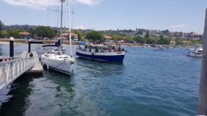
Whale Watching, Lunch and History Tours
Pick up and Drop off Rose Bay Pontoon Wharf, New South Head Rd, Rose Bay NSW 2029, Australia
Western End of Lyne Park 550 New South Head Road Rose Bay NSW 2029
Latitude 33°52’17.00″S Longitude 151°15’43.00″E
Some Car Parking is available – Fees may apply
The pontoon wharf is located the South East end of Sydney Harbour 100 metres south of the Rose Bay Ferry Wharf and metres north of Bus Stops on New South Head Road Rose Bay. Ferry Services are available to and from Watson’s Bay, Circular Quay, Milsons Point, McMahons Point, Balmain East, Barangaroo and Pyrmont Bay. Bus services are available to and from North Bondi, Edgecliff, Watsons Bay, Walsh Bay, Kings Cross, Edgecliff, Double Bay, City and the Rocks.
The wharf is also handy to cafés, fine dining restaurants, sea plane services and sporting clubs.
Vivid Dinner Tours
Pick up and Drop off King Street Wharf numbers 6,7,8 or 9 which are located on The Promenade down the stairs from the corner of Lime St and King St. Sydney.
Latitude and Longitude 33°52’6.53″S 151°12’4.43″E
Car Parking is available at nearby parking stations- Fees may apply
King Street wharves are located at the South end of Darling Harbour 400 metres south of the , Barangaroo Ferry Terminal, 500 metres walk from Wynyard Train Station and 800 walk from Town Hall Train Station.
These wharves are handy to the CBD, numerous hotels, cafés, restaurants, tourist attractions and shopping malls.
Charter and Event Pick up and Drop off locations
| Wharf Name | Nearest Street Address | Latitude and Longitude | Google Map Link |
| Rose Bay Pontoon Wharf | 550 New South Head Road Rose Bay NSW | 33°52’17.00″S 151°15’43.00″E | https://goo.gl/maps/upFz9LC5kPJf8HS76 |
| Yarranabbe Park Darling Point | 60 New Beach Road Darling Point | 33°52’17.07″S 151°14’6.00″E | https://goo.gl/maps/wrk9MZTu367x6hmQ7 |
| Clifton Gardens Wharf | Clifton Gardens Reserve Morella Rd Clifton Gardens NSW 2088 |
33°50’23.51″S 151°15’13.34″E | https://goo.gl/maps/22rDkyubJwsiXDE6A |
| Mosman Bay Ferry Wharf | 1E Avenue Rd, Mosman NSW 2088 | 33° 50′ 18.452″ S 151° 13′ 57.762″ E | https://goo.gl/maps/Yi67gKhTxWkbeYGV8 |
| Neutral Bay Ferry Wharf | 1 Hayes Street Neutral Bay NSW | 33° 50′ 30.963″ S 151° 13′ 8.269″ E | https://goo.gl/maps/Yeo3f1XRZtATyT2B7 |
| Eastern Pontoon Circular Quay | 7 Macquarie St, Sydney NSW 2000 |
https://goo.gl/maps/CCpUFhrVH8GfwhCD9 | |
| Campbells Cove 2 | 6A Circular Quay W, The Rocks NSW 2000 |
33°51’24.73″S 151°12’35.80″E | https://goo.gl/maps/22YcFCDADmJPVMW66 |
| Lavender Bay Jetty | 1 Lavender Cres Lavender Bay | 33°50’40.05″S 151°12’28.59″E | https://goo.gl/maps/6DZHQuA8iQ7NbVZY9 |
| Yeend St Balmain/Birchgrove | Yeend Street and Ronald St Ballast Point | https://goo.gl/maps/giwcvyfpav4ZZgDP7 | |
| King Street Wharf | 42 The Promenade, Sydney NSW 2000 |
33°52’6.53″S 151°12’4.43″E |
https://goo.gl/maps/RoFD2aGQv432SFQj9 |
| Pyrmont Bay Ferry Wharf | 50B Pirrama Road, Pyrmont NSW | 33°52’5.65″S 151°11’55.73″E | https://goo.gl/maps/GPEMwcxri8KN76yd7 |
| Casino Wharf | 48A Pirrama Road, Pyrmont NSW | 33°52’1.16″S 151°11’46.82″E | https://goo.gl/maps/GPQiEmdTGhL63Fb57 |
| Pirrama Park Pontoon Wharf | 20 Pirrama Rd
Pyrmont NSW 2009 |
33°51’52.67″S 151°11’27.67″E | https://goo.gl/maps/3YohkFPGdv8jbMbk8 |
| Deckhouse Wharf Woolwich | 1 Clarke Rd, Woolwich NSW 2110 | 33°50’28.62″S 151°10’27.40″E | https://goo.gl/maps/3AZ8JpZhBUQY3yRu5 |
| Greenwich Wharf | 21 Bay Street, Greenwich NSW | 33°49’57.30″S 151°10’43.25″E | https://goo.gl/maps/mq54MbYPX6oXuEZm7 |
| Longueville Wharf | Stuart St, Longueville NSW 2066 | 33°50’10.10″S 151°10’9.87″E | https://goo.gl/maps/dyAjjQKXfs5FDQrQA |
| Birkenhead Point Ferry Wharf | 1 Henley Marine Dr, Drummoyne NSW 2132 | 33°51’27.69″S 151° 9’40.60″E | https://goo.gl/maps/usNJvsbRibKzBzFh6 |
| Drummoyne Wharf | 2 Wolseley St, Drummoyne NSW 2047 | 33°50’43.66″S 151° 9’25.61″E | https://goo.gl/maps/vyyoJjz5PSp9Eyyg6 |
| Bedlam Point Wharf |
40 Punt Rd, Gladesville NSW |
33°50’27.14″S 151° 7’38.34″E | https://goo.gl/maps/XLd2dMXmvjhm2Uhr5 |